Grand Canyon Discussions
These are from my previous discussions of the Grand Canyon.
- Earth's Surface
http://www.thunderbolts.info/forum/phpBB3/viewtopic.php?f=4&t=5769&start=135#p67787
http://www.thunderbolts.info/forum/phpBB3/viewtopic.php?f=4&t=5769&start=165#p71350
- U.S. Northwest
http://www.thunderbolts.info/forum/phpBB3/viewtopic.php?f=10&t=7086#p71222
- Jno Cook
http://www.thunderbolts.info/forum/phpBB3/viewtopic.php?f=10&t=7294
- Saturn Flares
http://thunderbolts.info/forum/phpBB3/viewtopic.php??f=10&t=10457&start=30#p79239
- C14 Dating
http://www.thunderbolts.info/forum/phpBB3/viewtopic.php?f=4&t=2992&start=60#p72183
- Cardona Interview
http://www.thunderbolts.info/forum/phpBB3/viewtopic.php?f=10&t=3824&start=90


Young Earth
© Lloydby Lloyd » Sat Mar 22, 2014 11:04 am
Coastal Erosion Rates Prove Young Continents
I read at least a couple years ago that coastal erosion disproves mainstream geological dating, but I had forgotten about it.
Continental drift very likely did occur, but it occurred very rapidly and very recently, not gradually and very long ago. See http://newgeology.us for details.
Coastal erosion and continental shelf sedimentation are proof against continental drift having occurred more than about 5,000 years ago.
This website, http://oceanworld.tamu.edu/resources/oceanography-book/coastalerosion.htm says: Average erosion rates are 6 feet per year along the Gulf and 2 to 3 feet per year along the Atlantic. [] Beatley, Brower, and Schwab (2002).
This video, http://youtube.com/watch?v=OCR6-nH3WMA, says most coasts worldwide are eroding faster than the Atlantic coast is, so that would be more than 2 feet per year. It also says the continental shelves are gaining a few feet of sediment per year.
Conventional science claims that most continental drift occurred over 200 million years ago. But if erosion has been going on for all that time, the coasts would have eroded 380 miles in 1 million years and 3,800 miles in 10 million years. So the continents would have all eroded into the oceans within 20 million years and there would be no land above sea level.
There is a lot of other evidence that the continents are young. Several major rivers are known to be less than 20,000 years old. That includes the Mississippi River.
I could include evidence from my old thread on the Grand Canyon etc too.by Lloyd » Sat Mar 22, 2014 12:13 pm
Continents Are Under 20,000 Years Old
The above info proves that the present continents are very young, but there was a supercontinent which broke up, leaving the present smaller continents etc. Determining the age of the supercontinent is harder to do. The breakup likely occurred about 4,500 years ago. Before that the supercontinent must have been rather flat, since all of the present mountain chains were likely formed during the breakup. The continents are formed from sedimentary rock, mostly shale, i.e. mud, which must have been deposited during the Flood. The supercontinent must have consisted mostly of clay soil.
Submarine Canyons
The submarine canyons on the east and west coasts of North America, near NYC and LA, must have formed while the oceans were down in those areas, because canyons don't form under water. When the ocean was down in the Atlantic, it was probably high in the Pacific and vice versa, as a huge tsunami moved around the globe and left a deep trough behind it, until the seas eventually settled into about the present level. The submarine canyons must have formed as the flood waters on the continents drained off into the nearly empty ocean basins. Tsunamis are said to travel at about 500 mph. Since the Earth is about 25,000 miles in circumference, it would take tsunamis about 50 hours, or about 2 full days, to go all the way around the globe.
Tsunami During Continental Drift
When North America broke away from Europe (due to an asteroid impact near east Africa), the Appalachian Mountains would have formed first on the east coast and a flood from the Pacific would have flowed across North America (that was just before the Rocky Mountains formed on the west coast, so there was nothing to stop the flood). This tsunami flood possibly formed the St. Lawrence seaway, the Mississippi River, the Hudson River and the Hudson canyon in the continental shelf near NYC, while the Atlantic Ocean basin was opening up and ocean waters were gradually starting to fill it from the south and the north. After about 12 hours of North America sliding over the Moho layer, the west coast would have begun to run over the east Pacific ridge, causing western North America to become elevated, and as the plate movement slowed, friction would have increased, causing the Rocky Mountains for form. When the plate stopped, some of the flood waters would have poured off of California as the Pacific Ocean waters now were moving away from shore, due to inertia, and the canyon near LA would have formed from the retreating flood waters.
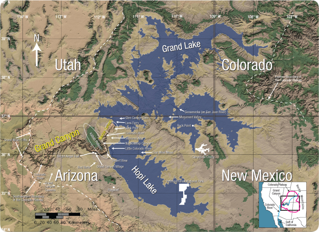
Grand Canyon
The flood waters left two large lakes just north and east of the present Grand Canyon location, called Grand and Hopi Lakes. When the lakes breached the plateau, maybe 200 years after the supercontinent breakup event, the canyon formed from the ensuing water flow through the breach in the plateau, when the sediments were still somewhat soft.
http://geology.isu.edu/Digital_Geology_Idaho/Module14/mod14.htm
http://www.creationscience.com/onlinebook/IntheBeginningTOC.html
http://hugefloods.com/LakeMissoula.html