home


Jet Streams & Feeder Bands
© Charles Chandler
 
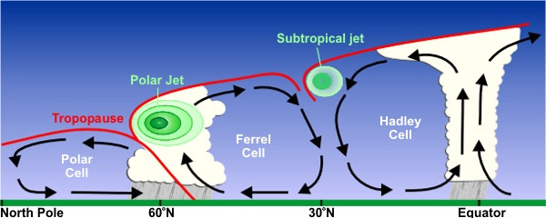
Jet streams are curious phenomena, as "rivers of wind" within the atmosphere, sporting much higher velocities (as much as 120 m/s). The laminar flow proves that the wind is being pulled by a low pressure — a high pressure that pushes wind creates a turbulent flow. But what enables the jet streams to move so much faster than the surrounding air?
 
 
Figure 1. Jet stream overview, courtesy NOAA.
 
Figure 2. Jet stream profile, courtesy NOAA.
 
 
In fluid dynamics, whenever there are differential speeds, it is evidence of differential viscosities, and the fluid with the lower viscosity travels faster. So then the question is: what lowers the viscosity such that the jet stream can flow faster?
 
There are 4 things that can lower the viscosity of air: lower densities, cooler temperatures, greater water vapor content, and greater positive charges.
 
In the case of the polar jet, which occurs where the Ferrel Cell is getting undercut by the Polar Cell, it isn't because of cooler temperatures, because the thunderstorms release heat. And it isn't because of greater water vapor content, because at the top of the troposphere, almost all of the water vapor has already condensed into ice crystals or supercooled aerosols. This leaves only the greater positive charges from the anvils of the storms as the source of the lower viscosity, where the repulsion of like charges prevents the particle collisions that instantiate friction inside the fluid (i.e., viscosity).
 
The subtropical jet is more likely the consequence of lower densities and cooler temperatures.
 
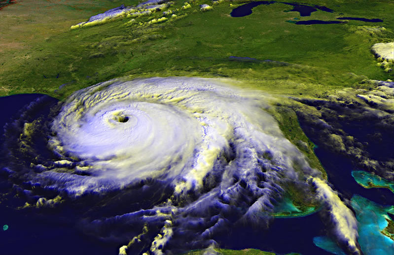
A related phenomenon is the enhanced inflow into tropical cyclones in the feeder bands. All other factors being the same, we'd expect the turbulence from the thunderstorms in the feeder bands to reduce the velocity, and for the inflow to have to find its way around the storms. We'd also expect the cold downdrafts to have little convective potential, and if that's the air supply to a tropical cyclone, we are left without an explanation for the powerful & sustained updraft in the eye wall.
 
 
Figure 3. Hurricane Ivan, 2004-09-15, courtesy NASA.
 
 
Only if the thunderstorms are increasing the ionization of the air will its viscosity drop, enabling a faster inflow, despite the turbulence due to the thunderstorms. Ionization also encourages evaporation, enabling the air to absorb more water vapor, and thus build up more latent heat that can be released in the eye wall.

← PREV Powered by Quick Disclosure Lite
© 2010~2021 SCS-INC.US
NEXT →